
Progress carries within itself the seeds of its own destruction. The glory of conquest will eventually witness its celebrants gone; its purpose mostly forgotten. The promise of life will wend its way through time-with varying degrees of longevity-to the inevitable conclusion. For California, the brave and brazen attempt to settle an uncharted territory in 1769 will be rewarded within a short period of time only to witness its agonizing destruction as time extracted its toll in deterioration and near oblivion. From a mission settlement to the county seat (all within 100 years), San Luis Obispo was forced to change.
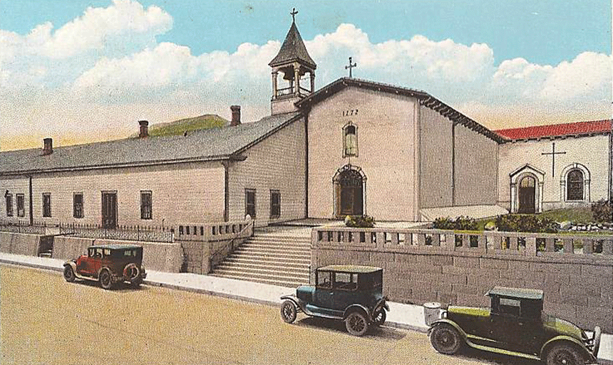
Not so the land. Its use evolved until streets replaced steers and commerce replaced crops, but the dirt accepted all. For the land in front of the mission, it became an avenue of advancement as automobiles replaced horses and the city fathers renamed the street “Monterey” from “Mission.” The vibration of traffic replaced the vibrancy of the past.
That is not to say San Luis Obispo simply became an isolated conglomerate of people and problems. The community was home for about 15,000 residents by the mid-twentieth century with many tracing family ties to the earliest settlers. Hosting the annual La Fiesta celebration brought visitors by the thousands into the community in addition to the more temporary residents attending Cal Poly. It was not some derelict stopping place between the increasingly unlivable megalopolises of Los Angeles and San Francisco.
It was, however, aging with varying degrees of grace. There was an emerging consensus to invigorate the downtown shopping streets to maintain business and civic income. What better place to start than in front of California’s oldest mission structure? As so often happens with great events, the renaissance came quietly and nearly anonymously with no intention of inaugurating the near civic war.
The story continues …
There was little chance the main streets or area surrounding the Mission in the late 1940s would be nominated for Downtown Beautiful. Many structures and homes–while not as old as the Mission–were simply allowed to age. Thus, the center of San Luis Obispo was dominated by an accumulation of structures with little to recommend them. Here and there, the City was home to some architecturally superior buildings and residences but city planning was either unknown or little appreciated as a community function.
As an assignment in the late 1940s, junior college art teacher, Margaret Maxwell, asked students to provide artistic suggestions to revitalize the aging downtown. One depicted a plaza in front of the Mission with Monterey Street closed at Chorro Street to through traffic. It was labeled the Mission Gardens. Given the yearly influx of visitors for the Fiesta de los Flores, it would be an excellent site for locals to sell their creations. An academic assignment became the backdrop for some 30 years of civic debate.
The Soroptimist service club liked the idea of highlighting the community center and asked the City Council to pursue the concept. The City fathers dominated by downtown merchants were tepid in their response as the goal was to increase parking spaces, not to reduce them. Eliminating curb parking was not considered a worthy objective. Too often, bureaucracy forgets who owns the bureau, and the citizenry refused to go away.
Next, an aged building on the corner of Monterey and Chorro Streets was razed in the summer of 1954 revealing the San Luis Creek. Older than the city, the exposed creek was not today’s environmentally protected waterway but a liquid dump worthy of its own story. At the time, however, the possibility of a creek meandering through town simply enhanced having some open space next to it. Then, and now, the creek was not a municipal property as neighboring parcels were legally entitled to half of the creek bounded by Monterey and Higuera Streets.
Once again, a design concept slowly led to civic confrontations. Responding to a $75 prize offering, Cal Poly students submitted proposals for a revitalized civic center. The winning design suggested the closing of Monterey at Chorro. Again, the City Council was not about to embrace the plan and–in one of bureaucracy’s favorite pastimes–created another committee to explore the possibilities and costs to not only close the street but purchase the buildings along the creek to expand the municipal park, or create more parking spaces.
There was a possible mini-park using the site of the razed building and everyone agreed to the idea. It would take five years to become a reality with continued interest in something happening in the area. One resident suggested turning the creek into a two-decker parking facility “or just pave the bottom and use it when dry, or a scenic roadway.” Another, hopefully in jest, suggested removing the Mission to facilitate more shops and parking!
Differing views settled into two diametrically opposed ideas: close Monterey and create a community plaza or widen and possibly realign the street with part of the creek, covered to increase more parking. In varying arguments and proposals, the battle lines remained unchanged for the next 15 years.
In the meanwhile, another empty property on the opposite corner of Monterey and Chorro became available and would through a gift become part of the Mission acreage. Thus, there were now two open parcels as sentinels to the street in front of the church.
There were no dramatic town hall meetings or protests to launch the community’s revitalization–with or without a central plaza–but there was agreement that something, anything, needed to be accomplished to rejuvenate the downtown.
It was during these years that the City Engineer, the future mayor, Dave Romero, started planting trees along the main streets. It was also the beginning of a move to purchase properties facing the mission to allow expansion and realignment of Monterey–a five year, near quarter of a million-dollar expenditure. The only remnant today is the Murray Adobe. Along with a street name, it remembers one of the community’s pioneers, Walter Murray and his family.
There were studies and committees, both official and citizen generated, to continue building the envisioned improvement pyramid abundantly supplied with emotional tinder ready to burst into an open blaze. All that was needed was a source to ignite an inferno.
Once again, some hapless students became the culprits. It came about in 1967 when the city granted $750 to three Cal Poly architecture majors to develop concept drawings for the downtown. Not only the city council but downtown merchants and many residents took an active interest in the results.
It came in early June 1967 and the results were first, figurative barracks, and, then, literal barracks as the community girded itself for the eventual showdown.
Contact: jacarotenuti@gmail.com. Visit: www.joefromslo.com.